The Proposal
Vision – Responsible Development is our Guiding Principle
If approved, the scheme would be delivered by Mountpark who are committed to delivering a high-quality multi modal logistics campus. This means developing a campus which creates an attractive working environment and which has responsible development as a guiding principle. This will translate into both the built and natural environment within the scheme, underpinned by enabling a shift from road to rail as part of a more sustainable logistics sector in the UK.
- A new rail freight interchange, connected to the Chiltern Main Line;
- Approx. 6.5m sq. ft. (approx. 603,870 sq.m.) of rail served warehousing;
- Substantial new landscaping and green infrastructure, incorporating sustainable drainage systems (‘blue’ infrastructure);
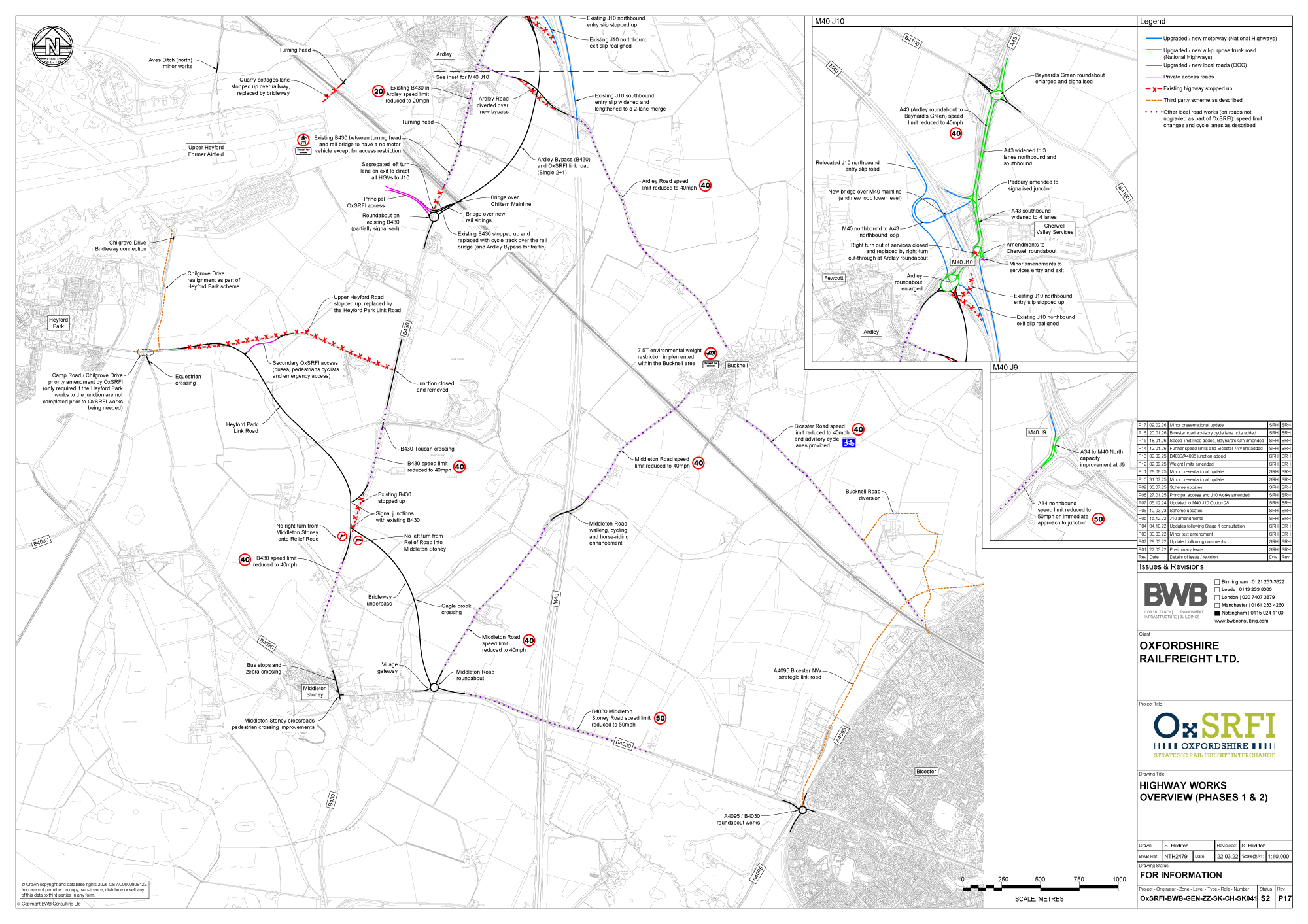
- Significant highways improvements including:
- Improvements to Junction 9 and Junction 10 of the M40;
- An Ardley Bypass to the east of Ardley – the Bypass is proposed from the Ardley Roundabout on an alignment east of the B430, and would also serve as the Principal Access to the Main Site. The B430 would be stopped up through Ardley , removing all vehicular through-traffic (accept for access);
- A Heyford Park Link Road from the B430 – a new single carriageway road which will provide a link from the B430 north of Middleton Stoney to Heyford Park, tied into Camp Road. The Main Site’s secondary access for buses, emergency vehicles, cyclists and pedestrians will be formed from this new link;
- A Middleton Stoney Relief Road – a new single carriageway road to the north-eastern side of Middleton Stoney which will provide a link from the B4030 to the B430 north of Middleton Stoney running to the north-east of the village;
- The principal vehicular access to the Main Site will be from the new Ardley Bypass and from a new roundabout on the B430 – all HGV traffic accessing the site will have to use this primary access. A secondary access from the proposed Heyford Park Link Road would allow bus, cycle and pedestrian (plus emergency) access only.

Some key components of the scheme are:
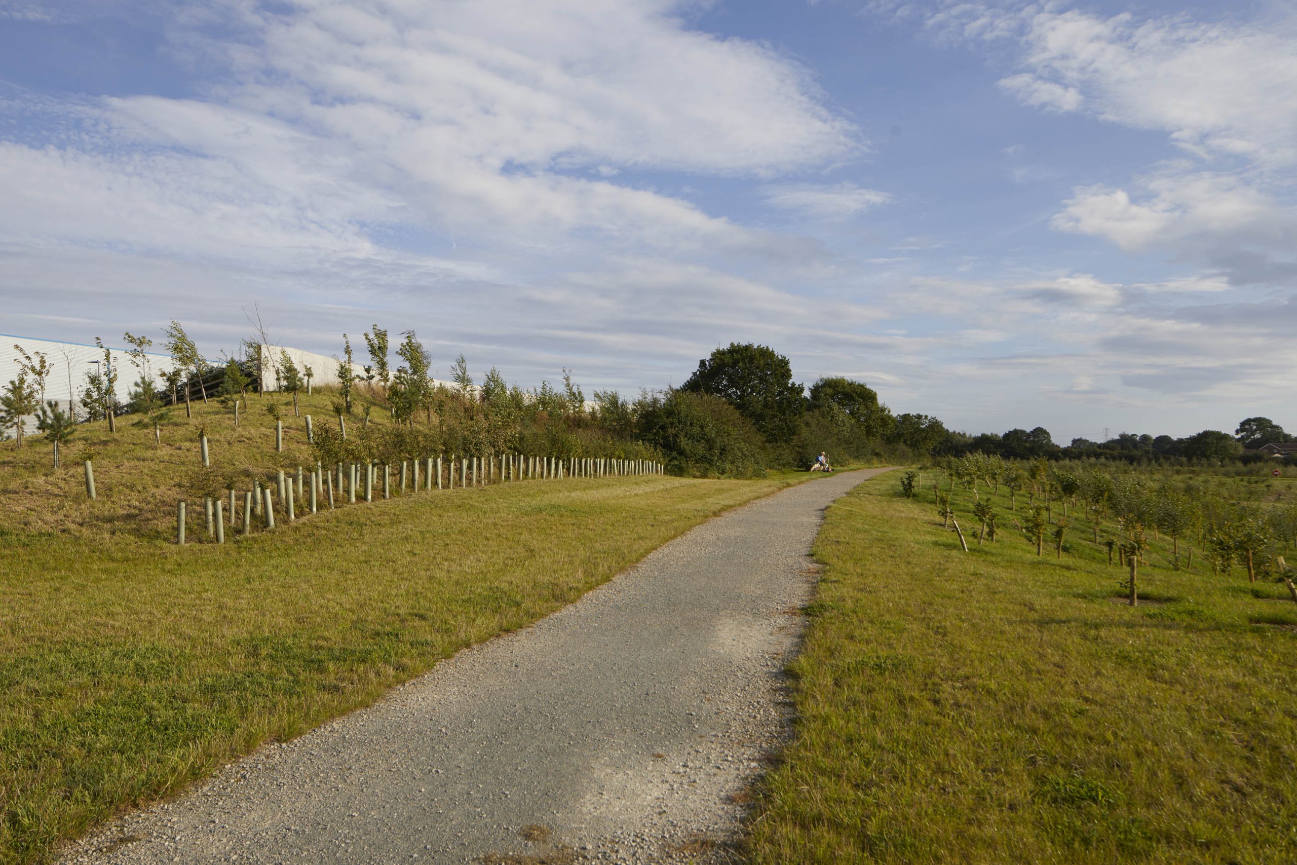
- around 60% of the total Site will be landscaped green space (new or retained), and habitat areas which will contribute towards a biodiversity net gain.
- the scheme will involve the planting over 60ha of new woodland and over 13km of new hedgerow.
- buildings and freight activity will be substantially screened by landscaped mounding.
- the proposals will play a direct role in enabling the transition to a more sustainable economy with rail freight being around 76% more carbon efficient than road freight.
- striving to reduce embodied carbon in construction and delivering a minimum BREAAM ‘Excellent’ but targeting ‘Outstanding’, and a minimum EPC rating of ‘A’ and targeting ‘A+’.
- designing to reduce energy demand and consumption and to include on-site renewable energy such as PV panels.
- The scheme will create a high-quality campus environment – prioritising employees health and wellbeing, with walking and cycling routes and trim trails and proposals to deliver wider amenities at the ‘central hub’ likely to include such uses as a café, education and training rooms, and recreational spaces.
Design Response to the Site and Context
The OxSRFI masterplan responds to the local context and seeks to maximise the benefits offered by the site’s specific characteristics and location.
This includes the sites topography which provides opportunities to reduce ground levels in parts of the site and create earthworks bunding to help substantially screen built development with strong landscaped edge and buffers around the Main Site. Although it will not be possible to entirely eliminate views of the proposed buildings from all viewpoints, the earthworks and landscape strategy is being developed with the intention to make views of the Proposed Development as sympathetic as possible. The combination of the existing topography, new earthworks and existing and new woodland planting will establish an effective visual screen and ‘buffer’ from many nearby locations.
Key potential environmental constraints onsite which influenced the proposals include the presence of an existing water-course and existing woodland areas which warrant retention, and a listed building within the site. However, some of these features also present opportunities for the proposed development.
Key examples include:
- retention of the listed building as part of the ‘central hub’ area which will provide amenities and facilities to support and enhance the experience of users of the site; and,
- retention of existing trees and woodland associated with the watercourse which are proposed as part of the extensive ‘green infrastructure’ and landscaping within the site.
Further details are shown on the Illustrative Masterplan which shows the site and the structural landscaping framework proposed.
Illustrative Masterplan


Around 60% of the total Site area is proposed as Green Infrastructure and Landscaping
The proposals include in excess of 60 hectares (ha) of new native woodland, scrub and tree planting – significantly in excess of the existing trees/ woodland to be lost
The proposals will see around 150,000 new native trees and other plants;
In excess of 13km of new native and species rich hedgerows planted;
Over 6ha of wetland and waterside habitats.
Access and Transport
The Proposed Development is in a highly accessible location, adjacent to Junction 10 of the M40, and with good access to the A43 and A34 which provide connections to key distribution markets including London and Birmingham, but also to the south-coast ports. This is key to the requirements of an SRFI, and part of what makes it an NSIP.

Significant growth (housing and population) is planned locally at Bicester and Heyford Park, and the site also has easy access to key urban centres including Oxford and Banbury. The Transport Assessment (TA) is assuming worst-case scenarios in terms of potential traffic based around the highest likely employment assumptions. Once fully operational the proposed development is forecast to generate up to 1000 car trips and 300 HGV trips during the morning and evening peak hours and when the range of proposed Travel Plan measures are operational. In order to accommodate the traffic associated with the scheme the proposals will deliver significant investment and physical improvements to the highway network.
The transport strategy was informed by detailed highways modelling using the locally approved traffic model, and was scrutinised by a Transport Working Group (TWG) including National Highways, Oxfordshire County Council and Cherwell District Council. The TWG was in place since 2020.
- significant improvements to M40 Junction 10 which will increase capacity and improve journey times – this includes works at Ardley, Cherwell, Padbury and Baynard’s Green roundabouts around Junction 10;
- all through traffic removed from Ardley village via the proposed new Bypass.
- significant reductions in the level of traffic passing through the centre of Middleton Stoney due to a proposed Relief Road.
- A much improved network of high-quality pedestrian and cycle routes around the wider area, linking in to and enhancing the Bridleway/PROW network.
- Improvement works at M40 Junction 9 to reduce queuing on the A43 approaching that junction.
In addition to new highways, and walking and cycling infrastructure, the proposed approach is to provide a flexible Public Transport Strategy which will allow new bus services at a frequency and hours of operation to respond to occupier (employer) requirements as the Proposed Development is built out. This will ensure that the bus services are suitable to serve the principal settlements from which the employees are sourced, maximise their usefulness and relevance, and ensure the bus services are commercially sustainable in the long run. A major focus is on providing a frequent bus service between the Main Site and Bicester, complementing the strategy established for the adjacent Heyford Park development. The strategy includes a new bespoke 15-minute frequency bus service during peak hours and shift change times direct to Bicester, which would loop through the Main Site and route along the Middleton Stoney Relief Road.
Economic Benefits
The logistics and distribution sector has a diverse range of skills and qualification requirements, and strategic sites such as this typically create a range of new job types. The range and types of jobs created reflect the important role played by the office content of the buildings which will be delivered, and trends across the sector show an increasing proportion of technical, supervisory, and managerial roles. Many strategic logistics buildings will see co-location of HQ type functions, as well as warehouse based roles and functions, as well as a need for notable IT and engineering specialisms where there is automated racking or similar in the warehouse.
Based on trends in the distribution sector, around a quarter of jobs will be defined as ‘highly skilled’. The typical breakdown of jobs in this sector would generally include:
%
driving roles
%
in office based roles including Information Technology, customer service, sales, and engineering support
%
in managerial roles
%
other roles.
Typically around 80% of all jobs would be full-time, with the remaining 20% part-time, and there would be a mixture of shift based as well as standard hours jobs. The assessment of economic benefits is based on an area derived from Census data regarding travel to work patterns. The employment and economic impacts of the scheme are likely to be focused on Oxfordshire, particularly the area around Bicester.
Gross Value Added (GVA) as a measure of economic value from the proposals is estimated to be around £361 million per annum. That represents a significant investment in the local economy and is in addition to the capital costs of development which are likely to be c£1bn. The construction process would also generate a mixture of temporary and permanent employment, over the construction period.

Focus on renewable energy generation and buildings which meet at least BREEAM ‘Excellent’ standards and a minimum EPC Rating of ‘A’, targeting ‘A

Creation of around 9,600 jobs – plus even more in the supply chain

Delivering training
and apprenticeship
opportunities

Generating Business
Rates of around £21
million annually

£361 million Gross
Value Added
annually
Committed to delivery of 10% Biodiversity Net Gain

Rail freight produces 76% less CO2 emissions than HGVs/road freight (NPS 2024)

Connectivity to major deep sea ports (Felixstowe, London Gateway and Liverpool)
Each freight train can remove up to 76 HGVs from our roads, lowering carbon emissions and reducing congestion (NPS 2024)